Jumat, 22 Juni 2012

Fueling great nonprofits with technology

Technology can make collaboration easier, cut costs and help operations run more efficiently. Unfortunately, the organizations trying to solve some of the world’s most difficult problems—nonprofits—often lack resources to fully take advantage of technology to further their causes.

That’s why we worked with the HandsOn Network, a Points of Light Enterprise, to create HandsOn Tech, an initiative that pairs U.S. nonprofits with individuals who are passionate about technology and looking to make a difference. Last year, we funded 24 full-time AmeriCorps VISTA positions. These VISTA members provided technology training to more than 1,300 small, poverty-focused nonprofits nationwide. Further, these VISTA participants engaged skilled volunteers, including lots of Googlers, to assist nearly 200 nonprofits in creating individualized, comprehensive tech plans that will help them to work more efficiently.

Each HandsOn Tech VISTA project varies based on different nonprofit needs. In the past year, projects have included:

  • Migrating Dreams for Kids, a Chicago nonprofit empowering at-risk and disabled youth, to Google Apps—enabling them to more efficiently and effectively collaborate without the restriction of limited office space.
  • Building a dynamic website and social media strategy for Doing Art Together, a NYC-based nonprofit providing hands-on programming and GED prep for under-resourced youth.
  • Using Google Maps and Fusion Tables to help Atlanta’s The Drake House create a map that helps staff better visualize the local homeless population in order to more effectively distribute their services.

HandsOn Tech Pittsburgh hosted a panel on social media tools, including Google+, Twitter, Facebook and LinkedIn, with local nonprofits at the Google Pittsburgh office

The program has been so successful that we’re expanding—it will now include one additional city and 28 new VISTA positions, with the goal of reaching even more nonprofits. The new HandsOnTech VISTAs will start in August with a one week training at our campus in Mountain View, Calif., where they’ll learn about cloud-based tools from a variety of technology companies including the Google For Nonprofits suite that allows many nonprofits to use free online advertising, Google Apps and YouTube channels. Once they are armed with tech know-how they’ll spend the rest of the year in two and three-person teams serving nonprofits in the Bay Area, Atlanta, Boston, Chicago, Detroit, New York City, Pittsburgh and Seattle.

HandsOn Tech is accepting applications for VISTA members now through June 27. If you’re passionate about technology and helping nonprofits on the front line of fighting poverty, then we hope you’ll apply!

Rabu, 20 Juni 2012

The Endangered Languages Project: Supporting language preservation through technology and collaboration

The Miami-Illinois language was considered by some to be extinct. Once spoken by Native American communities throughout what’s now the American Midwest, its last fluent speakers died in the 1960s. Decades later, Daryl Baldwin, a citizen of the Miami Tribe of Oklahoma, began teaching himself the language from historical manuscripts and now works with the Miami University in Ohio to continue the work of revitalizing the language, publishing stories, audio files and other educational materials. Miami children are once again learning the language and—even more inspiring—teaching it to each other.

Daryl’s work is just one example of the efforts being made to preserve and strengthen languages that are on the brink of disappearing. Today we’re introducing something we hope will help: the Endangered Languages Project, a website for people to find and share the most up-to-date and comprehensive information about endangered languages. Documenting the 3,000+ languages that are on the verge of extinction (about half of all languages in the world) is an important step in preserving cultural diversity, honoring the knowledge of our elders and empowering our youth. Technology can strengthen these efforts by helping people create high-quality recordings of their elders (often the last speakers of a language), connecting diaspora communities through social media and facilitating language learning.


The Endangered Languages Project, backed by a new coalition, the Alliance for Linguistic Diversity, gives those interested in preserving languages a place to store and access research, share advice and build collaborations. People can share their knowledge and research directly through the site and help keep the content up-to-date. A diverse group of collaborators have already begun to contribute content ranging from 18th-century manuscripts to modern teaching tools like video and audio language samples and knowledge-sharing articles. Members of the Advisory Committee have also provided guidance, helping shape the site and ensure that it addresses the interests and needs of language communities.

Google has played a role in the development and launch of this project, but the long-term goal is for true experts in the field of language preservation to take the lead. As such, in a few months we’ll officially be handing over the reins to the First Peoples' Cultural Council (FPCC) and The Institute for Language Information and Technology (The LINGUIST List) at Eastern Michigan University. FPCC will take on the role of Advisory Committee Chair, leading outreach and strategy for the project. The LINGUIST List will become the Technical Lead. Both organizations will work in coordination with the Advisory Committee.

As part of this project, research about the world’s most threatened languages is being shared by the Catalogue of Endangered Languages (ELCat), led by teams at the University of Hawai’i at Manoa and Eastern Michigan University, with funding provided by the National Science Foundation. Work on ELCat has only just begun, and we’re sharing it through our site so that feedback from language communities and scholars can be incorporated to update our knowledge about the world’s most at-risk languages.

Building upon other efforts to preserve and promote culture online, Google.org has seeded this project’s development. We invite interested organizations to join the effort. By bridging independent efforts from around the world we hope to make an important advancement in confronting language endangerment. This project’s future will be decided by those inspired to join this collaborative effort for language preservation. We hope you’ll join us.

Selasa, 19 Juni 2012

Street View says "aloha" from Hawaii


Before joining Google, I lived in Hawaii for several years. Now, one look at a photo of palm trees swaying in front of an impossibly blue-green ocean transports me back to the islands—relaxing on the beach and listening to the sound of waves crashing on the shore. If one photo can do that for you, how would you feel if you had access to millions of them?


View Larger Map
The Kohala coast on the Big Island of Hawaii


Our newly expanded Street View coverage of six of Hawaii’s islands enables you to take a virtual vacation to paradise. Explore panoramic imagery of local beach parks, tropical rainforests, volcanic lava fields, oceanfront resorts and more. Can you feel the ocean breeze yet? Now let's do some digital island-hopping...

Oahu
We begin our island adventure on Oahu, home to the capital city of Honolulu and a number of popular destinations. This island has something for everyone, from the top surfing locations of Waikiki Beach and Waimea Bay, to the USS Arizona Memorial Museum and Iolani Palace for history buffs, to the home of the NFL Pro Bowl at Aloha Stadium. Fans of the TV shows “Lost” and “Hawaii Five-0” or movies like “Jurassic Park” will love looking around for filming locations at Kualoa Ranch.


View Larger Map
Kualoa Ranch on the island of Oahu


Maui
Hopping over to Maui, we can sunbathe at oceanfront resorts in Ka’anapali, hit the links on challenging golf courses in Kapalua and learn the hula at the famous Old Lahaina Luau. One of my favorite memories of Maui is driving along the scenic “Road to Hana” with my friends, an experience I can now relive with Street View.


View Larger Map
The “Road to Hana” on the island of Maui


Big Island
We now fly over to the island of Hawaii, also known as the Big Island, where we visit one of the most active volcanoes in the world at Hawaii Volcanoes National Park. We check out the scene in the funky seaside town of Kailua-Kona, explore tropical gardens in Hilo, and climb above the clouds on Mauna Kea. We end our Big Island sojourn with a little oceanside relaxation at the luxurious resorts in Waikaloa, Kamuela or Hualalai.


View Larger Map
Hawaii Volcanoes National Park on the Big Island


Molokai
Over on Molokai, people enjoy the quiet life. With no buildings taller than a coconut tree and not a traffic light to be seen, miles of untouched shorelines and excellent outdoor activities will help you leave the modern world behind.


View Larger Map
The untouched coastlines of Molokai


Kauai
Now let’s jump to the incomparable Kauai, with its jaw-dropping landscapes around every turn. Whether you’re staying in Poipu or Hanalei, be sure to visit Waimea Canyon, which Mark Twain called the “Grand Canyon of the Pacific”. You might also enjoy a leisurely stroll along the coast at Lydgate State Park.


View Larger Map
Waimea Canyon on the island of Kauai


Lanai
Our virtual tour of Hawaii comes to an end on the romantic, tiny island of Lanai, the “pineapple island.” This island has so many memories for me, from the day I proposed to my wife (a few hundred feet from here) to the morning we spent swimming with dolphins in Hulopoe Bay. I can’t wait to go back again!


View Larger Map
An upcountry retreat on the romantic island of Lanai.


We hope this little taste of Hawaii will inspire you to use Street View the next time you're planning a vacation—whether you’re taking a trip around the block, across the world or just down memory lane. Check out a more complete list of Street View’s off-the-road locations in Hawaii here or visit our Scenic Hawaii collection in the Street View gallery.


Street View car at Kualoa Ranch on the windward coast of Oahu.


Aloha!


(Cross-posted on the Lat Long blog)

Safe Browsing—protecting web users for five years and counting

In this post, we've collected some highlights from the past five years of our Safe Browsing efforts, aimed at keeping people safe online. See the Security Blog for the full details and more visuals. -Ed.

Five years ago, we launched Safe Browsing, an initiative designed to keep people safe from malicious content online. Our primary goal was to safeguard Google's search results against malware (software capable of taking control of your computer) and phishing (fraudulent websites that entice users to give up their personal information). We also wanted to help educate webmasters on how to protect their own sites.

Malware and phishing are still big problems online, but our Safe Browsing team has labored continuously to adapt to the rising challenges of new threats. We've also developed an infrastructure that automatically detects harmful content around the globe.

Here’s a look at the highlights from our efforts over the past five years:
  • We protect 600 million users through built-in protection for Chrome, Firefox and Safari, where we show several million security warnings every day to Internet users. When we detect malware or phishing, we trigger a red warning screen that discourages clicking through to the website. Our free and public Safe Browsing API allows other organizations to keep their users safe by using the data we’ve compiled.
  • We find about 9,500 new malicious websites every day and show warnings to protect users. These are either innocent websites that have been compromised by malware authors, or others that are built specifically for malware distribution or phishing. Our detection techniques are highly accurate—we have had only a handful of false positives.
  • Approximately 12-14 million Google Search queries per day warn users about current malware threats, and we provide malware warnings for about 300 thousand downloads per day through our download protection service for Chrome.
  • We send thousands of notifications daily to webmasters. When webmasters sign up for Webmaster Tools we give them the option to receive warning notices if we find something malicious on their site.
Malware and phishing aren’t completely solvable problems because threats continue to evolve, but our technologies and processes do, too.

Phishing and malware trends
Online commerce sites are still favorite phishing targets because phishers are motivated by money. Some tried-and-true phishing methods are still used, but attacks are also getting more creative and sophisticated. Attacks are faster, with phishers sometimes remaining online for less than an hour to try to avoid detection. They’re also more geographically dispersed and are getting more targeted.


Malware authors often compromise legitimate sites to deliver content from a malicious attack site or to redirect to an attack site. These attack sites will often deliver "drive-by downloads" to visitors, which launch and run malware programs on their computers without their knowledge. To try to avoid detection, these attack sites adopt several techniques, such as rapidly changing their Internet location with free web hosting services and auto-generated domain names. Although less common than drive-by downloads, we’re also seeing more malware authors bypassing software vulnerabilities altogether and instead employing methods to try to trick users into installing malicious software—for example, fake anti-virus software.

How you can help prevent malware and phishing
Our system is designed to protect users at high volumes, but people still need to take steps to keep their computers safe. Ignoring a malware problem is never a good idea—if one of our warnings pop up, you should never click through to the suspicious site. Webmasters can help protect their visitors by signing up for malware warnings at Google Webmaster Tools. These warnings are free and will help us inform them if we find suspicious code on their sites. Finally, everyone can help make our system better. You can opt-in to send additional data to our team that helps us expand the coverage of Safe Browsing.


Looking forward
Some of our recent work to counter new forms of abuse includes:
It’s a good feeling to know that we’re making the web more secure and directly protecting people from harm—whether they’re our users or not. We continue to invest heavily in the Safe Browsing team so we can defend against current and future security threats.

Senin, 18 Juni 2012

The Surui Cultural Map

This week we're at Rio+20, the United Nations Conference on Sustainable Development. We're sharing a series of posts about our activities at the conference on the Green Blog; in this cross-post we've gone into more detail about one announcement taking place there. -Ed.

This week at the Rio+20 conference, the Surui tribe of the Brazilian Amazon are launching their Surui Cultural Map on Google Earth. This represents the culmination of a unique five-year collaboration between the Surui people and Google, which began in June 2007 when Chief Almir Surui first visited Google and proposed a partnership. The story of that visit, and the remarkable project that followed, are told in a new short documentary also launching here at Rio+20: “Trading Bows and Arrows for Laptops: Carbon and Culture.”


Training the Surui youth as mapmakers
Over three visits to the Surui territory between 2008 and last month, our Google Earth Outreach team taught Surui youth how to take photos and videos and to collect stories from their elders (such as from the time before first contact with the modern world). Then they learned how to upload these to the Google cloud using tools like Picasa, Docs, and YouTube. From there we used Spreadsheet Mapper 3 to bind it all together to create a Google Earth KML of their map, which contains almost 300 sites.

Map highlights
Through this project, my team has learned that maps are an expression of culture. Mapmakers refer to the “atomic element” of a map as a point of interest, or POI. The Surui mapmakers created POIs that reflect their traditional culture’s close interdependency with their forest home. So instead of hotels and gas stations, on the Surui map you’ll find the locations of parrots and toucans, or the three kinds of trees necessary to make their bows and arrows. You’ll learn where to find the Acai trees (which provide delicious fruit as well as the thatch for their maloca longhouses), the locations of good hunting grounds for the porcao (wild pig), and where the jaguar roam (jaguars have particular spiritual significance to the Surui people and figure in their creation myth). There are also sites and stories of historical battles with other tribes and with the white settlers who started arriving after “first contact” in 1969. Here’s an example POI for the Jenipapo tree:

The text reads: “Jenipapo fruit is produced by the jenipapo tree, which reaches twenty feet high. From the meaty part of the green fruit, an ink is extracted with which human skin can be painted. This makes the fruit very important for the Surui, because the art of painting is always included in everything that they do, especially in celebrations and rituals. The art of painting is one of the things most valued by Paiter. Each occasion calls for a different type of painting.”

Here’s a rich storytelling tour of the Surui Cultural Map, narrated by Chief Almir and the Surui youth who were the star mapmakers:


As Chief Almir says at the conclusion of the Surui people’s Google Earth tour:
Without the forest, our entire culture would disappear. And without our culture, the forest would have disappeared a long time ago. It’s important to live in a sustainable way and to strengthen those whose livelihoods directly depend on a healthy ecosystem. We have a 50-year sustainability plan, which includes solutions for our territory. An example is the Surui Carbon Project, which uses technology to monitor the carbon stock of forest and trade it in the market for carbon credits. Our hope is that we can come together virtually and in person, and that we can find and implement solutions together.
It’s been a great honor for us to work with the Surui people and to experience their world view, especially to see how they blend their traditional knowledge and culture with modern technology. We’ve learned from Chief Almir that partnerships, consensus and collaboration are central; in that spirit, we’d like to thank our partners on this project: ECAM, Kanindé and Brazilian filmmaker Denise Zmekhol, who has documented the life of the Surui people for more than twenty years.

You can watch a video of the  tour or download it in English or Portuguese. To learn more about the Surui tribe, known as “Paiter Surui,” please visit www.paiter.org.


(Cross-posted from the Green Blog)

Energy efficiency in the cloud

We’re obsessed with building energy efficient data centers that enable cloud computing. Besides helping you be more productive, cloud-based services like Google Apps can reduce energy use, lower carbon emissions and save you money in the process. Last year, we crunched the numbers and found that Gmail is up to 80 times more energy-efficient (PDF) than running traditional in-house email. We’ve sharpened our pencils again to see how Google Apps as a whole—documents, spreadsheets, email and other applications—stacks up against the standard model of locally hosted services. Our results show (PDF) that a typical organization can achieve energy savings of about 65-85 percent by migrating to Google Apps.

Lower energy use results in less carbon pollution and more energy saved for organizations. That’s what happened at the U.S. General Services Administration (GSA), which recently switched its approximately 17,000 users to Google Apps for Government. We found that the GSA was able to reduce server energy consumption by nearly 90 percent and carbon emissions by 85 percent. That means the GSA will save an estimated $285,000 annually on energy costs alone, a 93 percent cost reduction.

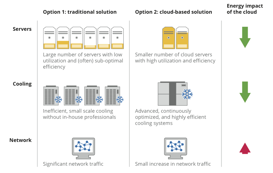
How is the cloud so energy efficient? It’s all about reducing energy use for servers and server cooling. Here’s how it works:


A typical organization has a lot more servers than it needs—for backup, failures and spikes in demand for computing. Cloud-based service providers like Google aggregate demand across thousands of people, substantially increasing how much servers are utilized. And our data centers use equipment and software specially designed to minimize energy use. The cloud can do the same work much more efficiently than locally hosted servers.

In fact, according to a study by the Carbon Disclosure Project, by migrating to the cloud, companies with over $1 billion in revenues in the U.S. and Europe could achieve substantial reductions in energy costs and carbon emissions by 2020:

  • U.S. companies could save $12.3 billion and up to 85.7 million metric tonnes of CO2
  • U.K. companies (PDF) would save £1.2 billion and more than 9.2 million metric tonnes of CO2
  • French companies (PDF) could save nearly €700 million and 1.2 million metric tonnes of CO2

We’ve built efficient data centers all over the world, even designing them in ways that make the best use of the natural environment, and we continue working to improve their performance. We think using the super-efficient cloud to deliver services like Google Apps can be part of the solution towards a more energy efficient future.

Posted by Urs Hoelzle, Senior Vice President for Technical Infrastructure

(Cross-posted on the Google Green Blog)

Minggu, 17 Juni 2012

More transparency into government requests

About two years ago, we launched our interactive Transparency Report. We started by disclosing data about government requests. Since then, we’ve been steadily adding new features, like graphs showing traffic patterns and disruptions to Google services from different countries. And just a couple weeks ago, we launched a new section showing the requests we get from copyright holders to remove search results.

The traffic and copyright sections of the Transparency Report are refreshed in near-real-time, but government request data is updated in six-month increments because it’s a people-driven, manual process. Today we’re releasing data showing government requests to remove blog posts or videos or hand over user information made from July to December 2011.

Unfortunately, what we’ve seen over the past couple years has been troubling, and today is no different. When we started releasing this data in 2010, we also added annotations with some of the more interesting stories behind the numbers. We noticed that government agencies from different countries would sometimes ask us to remove political content that our users had posted on our services. We hoped this was an aberration. But now we know it’s not.

This is the fifth data set that we’ve released. And just like every other time before, we’ve been asked to take down political speech. It’s alarming not only because free expression is at risk, but because some of these requests come from countries you might not suspect—Western democracies not typically associated with censorship.

For example, in the second half of last year, Spanish regulators asked us to remove 270 search results that linked to blogs and articles in newspapers referencing individuals and public figures, including mayors and public prosecutors. In Poland, we received a request from a public institution to remove links to a site that criticized it. We didn’t comply with either of these requests.

In addition to releasing new data today, we’re also adding a feature update which makes it easier to see in aggregate across countries how many removals we performed in response to court orders, as opposed to other types of requests from government agencies. For the six months of data we’re releasing today, we complied with an average of 65 percent of court orders, as opposed to 47 percent of more informal requests.

We’ve rounded up some additional interesting facts in the annotations section of the Transparency Report. We realize that the numbers we share can only provide a small window into what’s happening on the web at large. But we do hope that by being transparent about these government requests, we can continue to contribute to the public debate about how government behaviors are shaping our web.